Thermal Imaging Results |
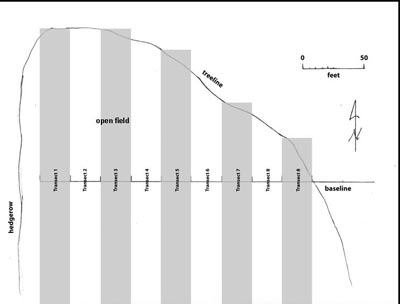
The survey was conducted by walking mapped transects, sweeping the thermal imager across paths 25 feet in width. This transect width provided adequate overlap between sweeps resulting in complete survey coverage. |
|
Three anomalies were noted and
mapped in the northern portion of the field, near the area that was most likely to contain the Andersons’
graves. One anomaly was an irregular circle that on visual inspection showed signs of surface disturbance
suggesting that it was an anthill. |
|
Next | |
Previous | |