Investigation of a |
The investigation was limited to a non-intrusive survey. Measurements of visible features
were taken by tape. Water temperature was 65 degrees F. Visibility varied from five or six feet
upon water entry to zero as sediment was disturbed by the work. The river bottom consisted of mud
and areas of shell.
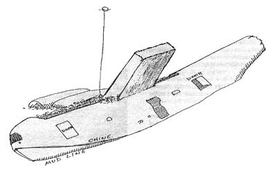
Sea moss, barnacles, and mussels covered the wreck structure. |
|
|
|
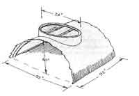
At its peak the wreck occupies 80% of the water column, rising 23 feet off the bottom in 30 feet of water.
Significant damage to the skin, framing, and other parts of the aircraft appears to have been caused
by the anchors of boats fishing on the wreck. Many small anchors and grappling hooks have been caught
in the structure, and the fuselage is festooned with fishing lines and lures. | |
A detached feature that may be the foundation of a dorsal turret or the "tunnel hatch" under the tail was located partially buried in the bottom silts approximately 150 feet east of the nose. |
|
| |
| |
Start | |