MAHS

MAHS Cherryfield Project

MAHS


Map data were correlated in GIS (Geographic Information System) and plotted on a digitized USGS quadrangle map.

The wreckage was found to be distributed over an area measuring at least 35 by 145 feet.   While most of the wreck was buried, frame tips appeared just above the sediment in some areas (blue points in the plot below).   No remains were encountered above the turn of the bilge.


plot of frames


data recording


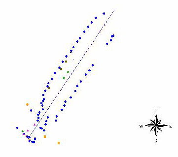
Frames near the bow measured 15 cm (6 in) wide and were spaced 20 cm (8 in) apart.   Hull planking measured 5 cm thick (2 in) and ceiling planking measured 7 cm thick (almost 3 in).   Moving aft the framing pattern changed.   The frames examined just aft of midships showed the connection of the floors and frames and what might be knees.   
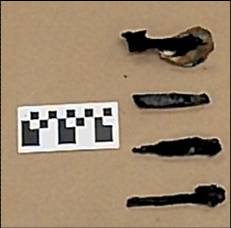
Iron fasterners, a sample of which is shown on the left, were common.


Interpretation   |

MAHS Project List